
Search from site
Looking for events? Check out the events calendar!
38 Search results, page 1/2
-
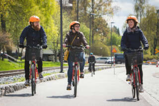
Cycling in Vaasa and the Vaasa Region
Information about interesting cycling routes, both in Vaasa and along the coast and surrounding Vaasa region, and also tips on bike rental.
-
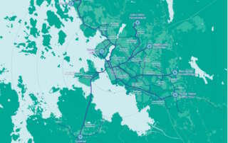
Marked Cycling Routes in Vaasa
Presentation of Vaasa's 7 main cycling routes. The routes follow bike paths, and there are signboards with route information along the routes.
-
Starting Point: The parking area is located next to Peippoos Disc Golf Course, along Peippoostentie just to the left shortly after the playground.
Length: Several circular routes ranging from 1 km to 3 km.
Difficulty: Easy.
Walking Time: Approximately 45 minutes for the 3 km route.
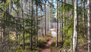
Adjacent to the parking lot is the gravel-covered Kylkkälä Fitness Trail, which is groomed in winter. Walking on the ski tracks is not allowed. There is also a disc golf course along with the fitness trail, so exercise caution regarding flying discs. The starting point of the nature trails is on the opposite side of Peippoostentie. The first 200 meters follow the pedestrian path uphill to the beginning of the trail, and the return point of the route is near the parking area. The nature trail is intended to be walked clockwise. The routes offer a true nature experience right in the vicinity of residential areas. The trail network is diverse, providing plenty of options for hikers. Along the nature trail, you’ll find a fireplace, and next to the fitness trail, there is also a lean-to shelter.
https://isokyro.fi/vapaa-aika-ja-matkailu/liikunta/luontoreitit/patikkareitisto/
-
Starting Point: The parking area is located at the end of Pohjantie.
Length: 1.4 km circular route (total length 2.3 km if taking the round-trip path to Isohaankallio).
Difficulty: Easy.
Walking Time: 30 min – 45 min.
You don’t need to go far to reach Lapinmäki. You can quickly embark on the hiking trail located right next to Isokyrö center. However, don’t let the proximity fool you; along the route, there are genuine nature experiences on an easily navigable trail. The starting point of the route is right next to the playground, making it an excellent destination for families with children.
https://isokyro.fi/vapaa-aika-ja-matkailu/liikunta/luontoreitit/patikkareitisto/
-
Start Point: Åbergintie 64.
Length: 11 km circular route.
Difficulty: Challenging.
Walking Time: 2.5-3 hours.
The Orisberg area has a diverse history, influenced by many key figures in Finnish history, from Zacharias Topelius to Jean Sibelius. The atmosphere around Orisberg Church is charming, and the starting point for the route is the bell tower, where, according to the tale, Sibelius and Aino Järnfelt got engaged. The route winds around Kotilampi through varied terrain on trails, duckboards, and forest roads. Those planning a shorter excursion can follow the hiking trail to Kotilampi cabin and return along the same path to the church. Those taking on the longer route continue from the cabin, circumnavigating the entirety of Kotilampi.
https://isokyro.fi/vapaa-aika-ja-matkailu/liikunta/luontoreitit/patikkareitisto/
-
Archive News
We got a total of 3902 feedback messages last year – thank you for each one!
We received 3902 feedback messages through Vaasa City’s feedback system in 2023. This was around 200 fewer than the previous year. The vast majority of feedback, 3414 messages, concerned the urban environment. We will continue to invest in responding to and utilising feedback, as feedback is an important part of the city’s development.
Read more We got a total of 3902 feedback messages last year – thank you for each one!
-
Starting Point: The trails can be accessed from two different points, either from the parking area of Ylipää Youth Association (Ylipään nuorisoseura) at Valtaalantie 403 or next to Lukkuhaan camping area at Kortesluomantie 157. Parking is only allowed in designated parking areas.
Length: Several circular routes ranging from 1-5 km.
Difficulty: Easy, with varying elevations.
Walking Time: Approximately 1 hour for a 5 km route.
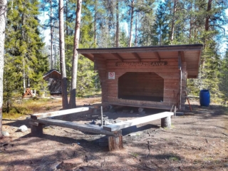
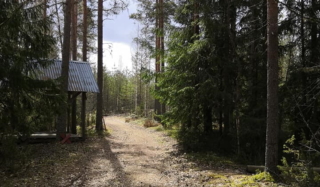
Ylipää’s diverse trails offer something for everyone. The area features versatile fitness trails of different lengths and several campfire sites. In the middle of the route, near Marjamäki observation tower, it is possible to take a break with a larger group, as there are two campfire sites there. The trail network is centrally located and easily accessible. The proximity of the camping area makes the trail a suitable destination for visitors to the area, approaching the route through forested landscapes up to the top of Marjamäki.
https://isokyro.fi/vapaa-aika-ja-matkailu/liikunta/luontoreitit/patikkareitisto/
-
Starting Point: Ventäläntie 670, parking only in the designated parking area, do not block the beginning of the trail with your car.
Length: 4 km circular route.
Difficulty: Moderate.
Walking Time: Approximately 1 hour.
The Tuomaanmäki area is a nature reserve that includes a Bronze Age burial mound. The mounds have been excavated, and stones have been removed. From one of them, apparently, all stones have been taken, leaving only a circular arrangement of stones locally referred to as “käräjäkivet” or judge’s circle. This is the origin of the place’s former name, Tuomarmäki. Tuomaanmäki is an environmentally and geographically splendid Bronze Age burial mound site with significant natural values. Along the route, hikers have the opportunity to explore ancient burial mounds, a “giant’s kettle” (which is not actually a giant’s kettle), diverse nature, and take a break at a campfire site. One of the stories from the mobile game “Tarinapolku” can be found here.
https://isokyro.fi/vapaa-aika-ja-matkailu/liikunta/luontoreitit/patikkareitisto/
-
In the area, there are hiking trails and lean-tos, as well as an approximately 8-meter high observation tower with stunning views. Firewood is delivered to the lean-tos a few times a year. During the winter, there are also unlit ski trails in the area. The Rajavuori hiking trail is approximately 5.5 km long, forming a circular route. The trail starts from the wilderness and hiking center.
From Rajavuori, there is a connection to Levälampi, a recreational area maintained by Metsähallitus on the border of Kurikka and Laihia. Levälampi is also connected to Jurva’s Pässilä and further to Kalajaisjärvi in Ilmajoki. The route is known as the “Kurjenkierros,” and the journey from Rajavuori to Kalajaisjärvi covers a distance of 30 km.”
https://laihia.fi/hyvinvointi-ja-vapaa-aika/liikunta/liikuntatilat-ja-alueet/ulkoliikuntapaikat/
-
Archive News
From a milk carton to a house: Variska’s second graders learned about recycling and programming during Energy Saving Week
7–13 October 2024 is National Energy Saving Week. The City of Vaasa is participating in the week, which includes a wide range of activities in schools, kindergartens, and elsewhere.
Read more From a milk carton to a house: Variska’s second graders learned about recycling and programming during Energy Saving Week
-
Archive News
Vaasa has new bicycle signage
New cycling signs and signposts have appeared on the streets of Vaasa during the autumn. The signage guides cyclists to different parts of the city and the most important sports and leisure facilities, educational institutions, and tourist attractions.
Read more Vaasa has new bicycle signage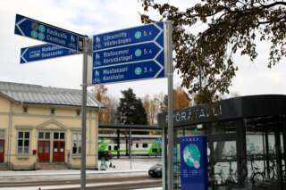
-
News
Vaasa schools developing energy education
The City of Vaasa has been awarded a special state grant for climate and sustainability education. The Inspiring Energy at School project supports sustainability education in schools by developing learning environments, producing materials, learning content and learning packages to support teaching, also in cooperation with external parties.
Read more Vaasa schools developing energy education
-
Archive News
School registration opens up in Vaasa 8.1.2024
The registration for the first grade in the compulsory education as well as the registration for the morning and afternoon care opens up on the 8.1 2024. Both registrations take place in the electronical system Wilma.
Read more School registration opens up in Vaasa 8.1.2024
-
Archive News
Apply for the Music Classes: application for preschoolers, second graders and sixth graders
Music Classes, that is, a learning path of basic education with special focus on music skills, has a long tradition in our city: we have had the Music Classes in Vaasa for over 40 years! Applications for the Music Classes are open in January and February for preschoolers, second-graders, and sixth-graders.
Read more Apply for the Music Classes: application for preschoolers, second graders and sixth graders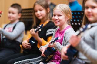
-
Archive News
Children’s voice is made even louder in Vaasa: work on the Child-Friendly Municipality model progresses
The City of Vaasa is participating in UNICEF’s model, where the goal is to be recognised as a Child-Friendly Municipality. This work progresses, as UNICEF has now approved Vaasa’s action plan, whose five goals will be implemented immediately.
Read more Children’s voice is made even louder in Vaasa: work on the Child-Friendly Municipality model progresses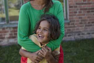
-
Archive News
Kynsiluoto is being cleared for a walking trail and the campfire sites are being fixed
The city-owned Kynsiluoto island in Vaasa is currently undergoing clearing work. The aim is to create a walking trail around the island and to refurbish the campfire sites along it.
Read more Kynsiluoto is being cleared for a walking trail and the campfire sites are being fixed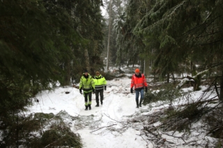
-
Archive News
Robots and recycling: bringing energy education to schools through various workshops
In May, students from Savilahti and Variska comprehensive schools got the chance to try out programming and train artificial intelligence.
Read more Robots and recycling: bringing energy education to schools through various workshops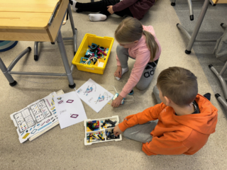
-
Archive News
The city has awarded the cultural grants for the year 2024
The City of Vaasa’s Culture Section has made decisions on the cultural grants for 2024. Grants and operating grants are awarded annually to various actors.
Read more The city has awarded the cultural grants for the year 2024
-
Lymmyysen nature trail is well-suited for families with children. The route offers various types of terrain, and along the way, there is information about different aspects of the area’s nature in the form of signs. It’s pleasant to conclude the excursion in a covered hut or log shelter while enjoying refreshments. The trail is located right next to Palhojaistentie, making it easily accessible.
- Starting point: From the point where Palhojaistentie 260 turns into a gravel road towards the parking area and the starting point of the trail.
- Length: 800m circular route
- Difficulty: Easy
- Walking time: 15 minutes to 30 minutes
- Map on the web page
- GPX-file available here.
https://isokyro.fi/vapaa-aika-ja-matkailu/liikunta/luontoreitit/patikkareitisto/
-
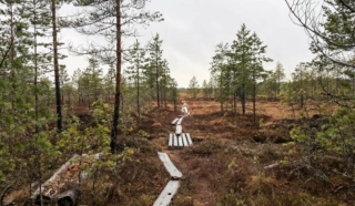
The initial part of the hiking trail on Fatisaari winds through varied terrain until vast bog landscapes unfold before your eyes. Thanks to over a kilometer-long boardwalk, you can admire the marsh landscapes with dry feet. Along this boardwalk, hikers can breathe in the scent of the marsh and take a break at the majestic rock on Fatisaari’s summit, where there is a lean-to shelter. Later, you get to enjoy the beautiful nature once again as you follow the same trail back to the starting point.
- Starting point: From Tulisalontie 525, turn onto Marjoniementie, continue until a narrow road turns right at Tuuralan hunting lodge. The trail is found at the end of this road. Park your car in a way that doesn’t obstruct other road users. Do not park in the hunting lodge yard!
- Length: Approx. 6 km round trip
- Difficulty: Easy
- Walking time: 1.5 to 2 hours
- Map at the web page
- GPX file available here.
https://isokyro.fi/vapaa-aika-ja-matkailu/liikunta/luontoreitit/patikkareitisto/